Search Term Record
Metadata
Name |
North Albany |
Related Records
-
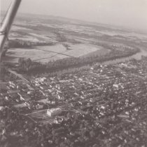
2008.260.aerial.033 - Photograph
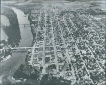
B/W aerial view of City of Albany, photo has been identified as looking northeast, lower left corner of photo is Whitespires Church, Linn County Courthouse, and United Presbyterian Church, left center of photo is Ellsworth bridge, Revere House, S.E Young building, Lyon and Broadalbin streets, center of photo is Willamette River, the Red Crown Mill, trestle bridge, and middle right of photo is Albany Union High School with North Albany across top ...
Record Type: Photo
-
2008.260.aerial.048 - Photograph
B/W aerial view of City of Albany, handwritten on back of photo in black ink "@9 3/4", "L2/ 11/ 3 1/4" below is stamped with black ink "GEORGE H. EHRLICH/ 1216 West 15th Ave./ Albany, Oregon 97321", below handwritten in black ink "Corner of Spring Hill Road & Hwy 20/ 1960's??" Building in center of photo identified to be Patio Restaurant. Willamette River at top of photo.
Record Type: Photo
-
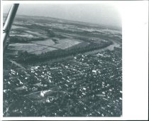
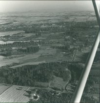
2008.260.aerial.050a - Photograph
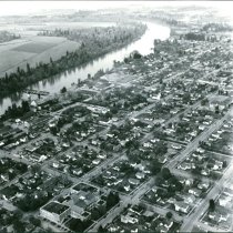
B/W aerial view of City of Albany, has been identified as early North Albany, Nebergall Loop in upper right of the photo.
Record Type: Photo
-
2008.260.aerial.050b - Photograph
B/W aerial view of City of Albany, has been identified as early North Albany, Nebergall Loop in upper right of the photo.
Record Type: Photo
-
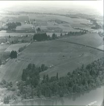
2008.260.aerial.052 - Photograph
B/W aerial view of City of Albany, has been identified as looking south from North Albany, grove of trees, farms and orchards in center of photo, downtown Albany in upper top of photo with the Linn County Courthouse, Whitespires Church, and First National Bank visible. On the back of the photo handwritten in pencil reads "1941"
Record Type: Photo
-
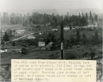
2008.260.aerial.057 - Photograph
B/W rooftop view of City of Albany, sticker with typed text attached to front of photo reads "Pre-1920 view from Gibson Hill. Peacock farm/ in center with windmill. Old Steel bridge and/ Linn County Court House with Clock tower shows/ at upper right. Thornton Lake bridge at left/ center. Williamson house still stands at left/ of Railroad crossing."
Record Type: Photo
-
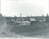
2008.260.aerial.058 - Photograph
B/W rooftop view of City of Albany, sticker with typed text on back of photo reads "North Albany Road, looking /South from RR Crossing." Houses, barns, and a windmill in center of photo, telephone poles and power lines poles along railroad tracks across the bottom of the photo.
Record Type: Photo
-
2008.260.aerial.091 - Photograph
B/W aerial view of downtown City of Albany, has been identified as looking east, left side of photo is North Albany, Willamette River and Calapooia convergence, old Steel Bridge, Ellsworth Bridge, and trestle bridge. Down the center of the photo are streets Water, First, Second, Third, Fourth and Linn County Courthouse, Fifth and Sixth going parallel. Streets Elm, Walnut, Maple, Vine, Calapooia, Washington, Ferry, Broadalbin, Ellsworth, Lyon, Bak...
Record Type: Photo
-
2008.260.aerial.095 - Photograph
B/W aerial view of City of Albany, has been identified as looking east, across the top of photo North Albany, Willamette River, Front street, Water, First, Second and Third streets, Midle right of phot is trestle bridge and Red Crown Mill, center of photo is Water street, First through Fourth streets, Lafayette, Thurston, Jefferson, Jackson, Railroad, Madison, Montgomery streets and Madison School. Albany High School lower left corner.
Record Type: Photo
-
2008.260.aerial.125 - Photograph
B/W aerial view of City of Albany, photo has been identified as looking northeast, lower left corner of photo is Whitespires Church, Linn County Courthouse, and United Presbyterian Church, left center of photo is Ellsworth bridge, Revere House, S.E Young building, Lyon and Broadalbin streets, center of photo is Willamette River, the Red Crown Mill, trestle bridge, and middle right of photo is Albany Union High School with North Albany across top ...
Record Type: Photo